Sale!


Original price was: $320.00.$97.99Current price is: $97.99.
- Safe Transactions, Happy Customers
- Superior Quality Goods
- Sustainable materials, for a better tomorrow.
- Prompt service, every time.

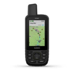
Make more time for adventure with this premium, rugged handheld. Get long battery life and multi-band technology for enhanced accuracy, plus preloaded TopoActive maps and access to satellite imagery.
- Sunlight-readable 3″ color display
- Multi-band technology and expanded GNSS support
- Vivid satellite imagery; downloads right to your navigator
- Active weather when paired to compatible smartphone
- Waterproof
- MIL-STD-810; bare unit only
- USB-C interface
- Rechargeable, internal lithium-ion battery
- Up to 180 hours of battery life in GPS mode and up to 840 hours in expedition mode
- Water-resistance rating: IPX7
- Memory / history: 16 GB (user space varies based on included mapping)
- Display resolution: 240 x 400 pixels
- Display dimensions: 2.5″H x 1.5″W; 3″ diagonal
- Dimensions: 6.4″H x 2.5″W x 1.4″D
- Weight with batteries: 8.1 oz.
Maps & Memory:
- Preloaded maps (TopoActive, routable)
- Ability to add maps
- Basemap
- Automatic routing for outdoor activities
- Satellite imagery (direct to device)
- Detailed hydrographic features (coastlines, lake / river shorelines, wetlands and perennial and seasonal streams)
- Searchable points of interests (parks, campgrounds, scenic lookouts and picnic sites)
- National, state and local parks, forests and wilderness areas
- RINEX logging
- External memory storage: 32 GB max microSD™ card
- Map segments: 15,000
- Waypoints / favorites / locations: 10,000
- Courses: 250, 200 course points per course
- Tracks: 250
- Navigation track log: 20,000 points, 250 saved GPX tracks, 300 saved fit activities
- Activities
- Navigation routes: 250, 250 points per route; 50 points auto routing
Sensors:
- High-sensitivity receiver
- GPS
- GLONASS
- GALILEO
- QZSS
- BEIDOU
- IRNSS
- Barometric altimeter
- Compass (tilt-compensated 3-axis)
- GPS compass (while moving)
- Multi-band frequency support
Daily Smart features:
- Connect IQ™ (downloadable watch faces, data fields, widgets and apps)
- Smart notifications on handheld
- VIRB® remote
- Pairs with Garmin Connect™ mobile
- Active weather
Safety and Tracking:
- Livetrack
Outdoor Recreation:
- Point-to-point navigation
- Tracback®
- Area calculation
- Hunt / fish calendar
- Sun and moon information
- Xero™ locations
- Geocaching-friendly
- Custom maps compatible (500 custom map tiles)
- Picture viewer
- LED beacon flashlight
inReach® features:
- inReach remote compatible
Outdoor Applications:
- Compatible with Garmin Explore™ app
- Garmin Explore website compatible
Connections:
- Connections wireless connectivity (Wi-fi®, Bluetooth®, ANT+®)
In the box:
- GPSMAP® 67
- Type A to type C USB cable
- Carabiner clip
- Documentation
Be the first to review “Garmin GPSMAP 67 GPS Handheld Navigator”
Related products
Sale!

Camping & Travel
Original price was: $30.00.$21.00Current price is: $21.00.
Sale!


Camp Stoves, Grills & Heaters
Original price was: $229.99.$97.99Current price is: $97.99.
Sale!

Camping & Travel
Original price was: $59.00.$41.30Current price is: $41.30.
Sale!

Camping & Travel
Original price was: $279.95.$95.99Current price is: $95.99.
Sale!


Camp Chairs, Cots & Tables
Original price was: $36.95.$25.87Current price is: $25.87.
Sale!


Camping & Travel
Original price was: $19.95.$13.97Current price is: $13.97.
Sale!


Bike Accessories
Original price was: $39.99.$27.99Current price is: $27.99.
Sale!

Camping & Travel
Original price was: $29.95.$20.97Current price is: $20.97.
Reviews
There are no reviews yet.